
Delhi Hailstorm 2026: Why Sudden Rain Hit NCR and What’s Next
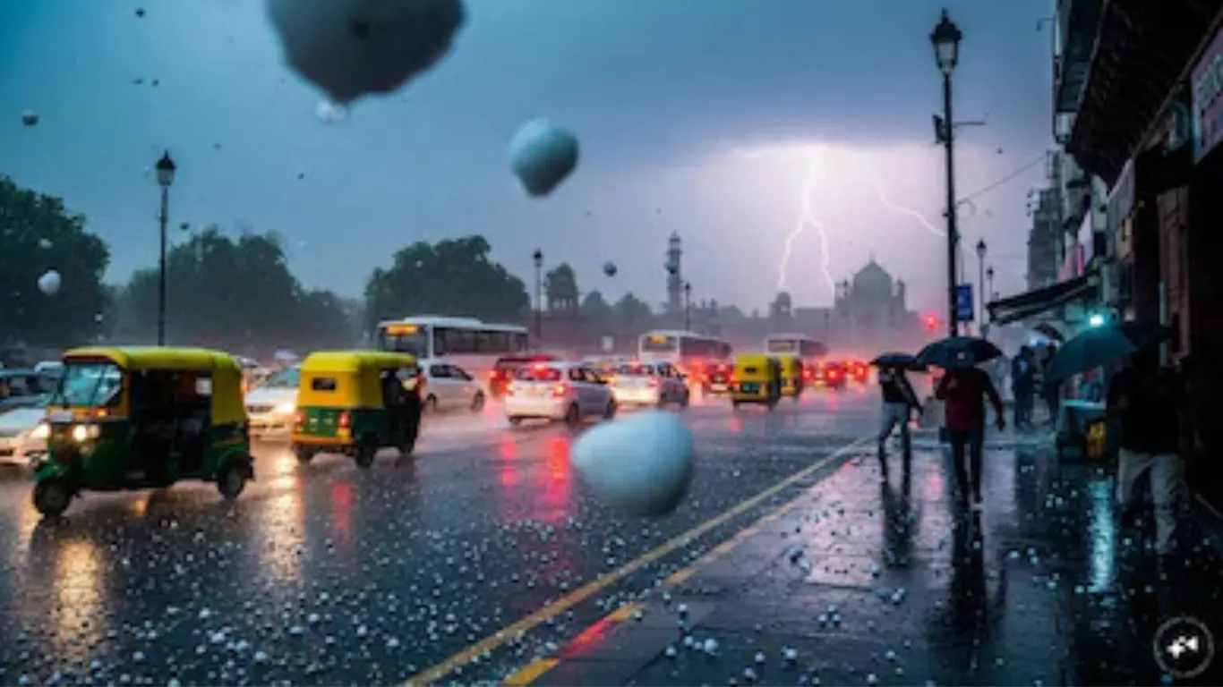
The Delhi hailstorm in May 2026 caught millions off guard. One moment, the capital was baking at temperatures nudging 44 degrees Celsius, and the next, the sky turned a strange bruised grey and ice pellets were bouncing off car rooftops in Gurugram. If you have been searching for what actually happened, why, and whether more storms are coming, this is the explainer you need.
What Triggered the Sudden Delhi Hailstorm and Heavy Rain
The answer is a western disturbance. That phrase gets thrown around in weather news without much explanation, so let us slow down and understand it properly.
A western disturbance is essentially a low-pressure weather system that forms over the Mediterranean and travels eastward across Iran, Afghanistan, Pakistan, and finally into northwestern India. It carries moisture with it. When this moisture-laden system collides with hot, dry surface air that has been sitting over north India for weeks, you get a violent reaction: sharp thunderstorms, gusty winds, and in some cases, hailstorms.
That is exactly what happened. The IMD weather alert issued in the days before confirmed that a fresh western disturbance was approaching. For Panipat, Sonipat, Delhi, Gurugram, and much of the Haryana weather zone, this translated into sudden hail and rain events that knocked temperatures down by nearly 8 to 12 degrees within hours.
Why This Matters More Than Just "Relief From Heat"
Here is the part the headlines skip. When a heatwave breaks this sharply and suddenly, it is not just weather news. It is a signal.
India in 2026 has been experiencing what climate scientists describe as increasingly erratic pre-monsoon weather. The India heatwave 2026 pattern has been especially severe, with parts of Rajasthan, Vidarbha, and Madhya Pradesh recording sustained temperatures above 45 degrees Celsius for days at a stretch. North India was not far behind. When the relief finally arrives, it does not come quietly. It arrives as a 70-kilometre-per-hour wind gust. It arrives as hail the size of marbles.
For farmers in Haryana and western Uttar Pradesh, hailstorm crop damage during this period is a genuine concern. Wheat harvesting season is still ongoing in parts of northern India, and unseasonal hail can damage standing crops before they are cut. That matters for households, not just for agricultural statistics.
How the IMD Forecast System Works (And Why It Gets Both Praised and Questioned)
The India Meteorological Department, or IMD, issued colour-coded alerts in the hours before the storms arrived. Orange alert for Delhi-NCR. Red alert for some isolated pockets. These alerts are not arbitrary. They reflect specific thresholds of wind speed, rainfall intensity, and lightning probability.
An orange alert means: be prepared. Expect disruption. Avoid open areas.
A red alert means: take action. Flights may be cancelled or diverted. That is exactly what happened at Delhi, Chandigarh, and Mumbai airports, where operations were disrupted as the storm system moved through.
Read More: UAE Quits OPEC Amid Iran War – Impact on Global Oil Markets & Prices
The IMD's 24-hour forecast accuracy has improved significantly in recent years, thanks to Doppler radar networks and better satellite data assimilation. However, hyperlocal prediction — whether your specific neighbourhood gets rain versus three kilometres away — remains genuinely difficult. That is not a failure of the system; it is a physics problem.
What People Keep Getting Wrong About Hailstorms
Most people assume hailstorms only happen in deep winter. That is not correct.
Hail forms when strong updrafts inside cumulonimbus clouds carry water droplets high enough into the atmosphere that they freeze. Pre-monsoon thunderstorms, which typically occur in April and May across north India, are among the most powerful updraft events of the year. The same energy that produces dramatic lightning and 80 kmph winds also produces hail. May hailstorms are actually relatively common in the Indo-Gangetic plain. They feel shocked because they follow such extreme heat.
Another common mistake: assuming the temperature drop will last. It usually does not.
Read More: Modi in Gangtok: What Sikkim's 50 Years of Statehood Really Means for India's Smallest State
What the Next Few Days Look Like for North India
A second western disturbance is already being tracked. According to IMD forecasts, another weather system is expected to cross into northwestern India shortly after the first one clears. This means the Delhi NCR weather forecast for the next 3 to 4 days remains unsettled, with intermittent rain, dust storms, and thunderstorm activity likely.
However, between weather systems, temperatures will attempt to climb back. This is the pattern: a brief cool spell, then a renewed heat surge as the western disturbance exits and dry, hot westerly winds resume. By mid-May, the pre-monsoon heat typically intensifies before the southwest monsoon begins its northward journey from Kerala, usually around late May or early June.
Practical Tips If Another Storm Warning Is Issued
Watch for the colour code before anything else. Green means normal. Yellow means watch. Orange means prepare. Red means act. Do not wait for red to make decisions.
Keep vehicles away from trees and open ground if a storm warning is active. Hail can crack windshields and dent bodywork in minutes. If you are driving when a hailstorm begins, pull under a covered structure or at minimum angle your car so the storm hits at a low angle rather than straight down.
For those with rooftop gardens or balcony plants — bring them inside. Heavy hail will destroy them in under 10 minutes.
Switch to reliable short-range forecast apps. The IMD's own application has improved considerably. Skymet also provides reasonably granular forecasts for north India.
Closing Thoughts
There is something quietly disorienting about standing outside after a May hailstorm in north India. The ground is still warm. Steam rises from the pavement. And yet ice pellets are melting in the grass. It feels like the atmosphere is contradicting itself.
In a sense, it is. The collision between an exceptionally hot land surface and a moisture-rich weather system produces exactly this kind of violent, brief reversal. These events are not going to become less frequent. If anything, climate trends suggest they will become more intense, more unpredictable, and more consequential.
Pay attention to the alerts. They are there for a reason.
Disclaimer: This article is based on information available across the web. Parchar Manch does not take responsibility for its complete accuracy, as the content could not be fully verified.
Read More: Google's $15 Billion AI Data Centre in Andhra Pradesh: Why Vizag Is About to Change India's Digital Map
FAQs
Why did it suddenly hail in Delhi and NCR in May 2026?
A western disturbance brought moisture-laden air from the Mediterranean into a region experiencing extreme heat. The collision of these air masses produced intense thunderstorms, gusty winds, and hail across Delhi, Gurugram, Noida, Panipat, and surrounding areas.
Is hail in May unusual for North India?
Not really. Pre-monsoon thunderstorm season (April to June) is actually one of the most active periods for hailstorms in the Indo-Gangetic plain. They feel surprising because they follow weeks of intense heat, but meteorologically, they are a known seasonal feature.
How long will the relief from heat last in Delhi-NCR?
Typically, 24 to 48 hours after a western disturbance passes. Another weather system is already approaching, which may extend the unsettled period. After both systems clear, temperatures are expected to rise again toward the mid-40s before monsoon onset.
What should I do when an orange or red weather alert is issued by IMD?
Avoid travel if possible, stay away from open fields, large trees, and flood-prone underpasses. Secure vehicles under covered parking. Keep your phone charged. Follow IMD or Skymet for updated bulletins every few hours, as conditions can change rapidly.
Will hail damage crops in Haryana and Punjab?
It depends on crop stage and intensity. Wheat is in late harvesting stages in many areas, so farmers should prioritise early harvesting of ready crops before another storm system arrives. Standing crops in early-cut fields face a lower risk.